Kanīna Khās night lights from space
Night Light of Kanīna Khās (Haryana) from space (India) Src. Average luminocity for 10x10km area is 2.3036% and for 50x50km: 4.5083%.
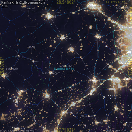
Analysis of Kanīna Khās night lights 2016
Square area 10x10 km:
 0%
0%90-99
0%80-89
0.79%70-79
0%60-69
0.2%50-59
1.39%40-49
0.6%30-39
0.2%20-29
0%10-19
0%0-9
96.83%Square area 50x50 km:
0.31%90-99
0.51%80-89
0.25%70-79
0.42%60-69
0.51%50-59
0.88%40-49
0.79%30-39
1.33%20-29
0.67%10-19
2.63%0-9
91.7%Clear (daylight) street map image can be seen on geolist.org.
Map coordinates:
28° 56' 52.9" North, 75° 36' 28.3" East
28° 19' 51.3" North, 76° 18' 39.6" East
27° 42' 36.8" North, 77° 0' 50.8" East
Some cities around Kanīna Khās sort by population:
• Rewāri
33.5 km =20.8 mi,  115°
115°
• Nārnaul
37.5 km =23.3 mi,  211°
211°
• Charkhi Dādri
29.2 km =18.1 mi,  352°
352°
• Jhajjar
45.6 km =28.3 mi,  47°
47°
• Mahendragarh
17 km =10.6 mi,  246°
246°
• Pataudi
45.8 km =28.5 mi,  90°
90°
• Bāwal
39.3 km =24.4 mi,  137°
137°
• Ateli Mandi
26.1 km =16.2 mi,  191°
191°
1268398 (p: 10,815)
Sources (retrieved 2019-11-25):
» Earth at Night: Flat Maps 2012, 2016