Bāwal night lights from space
Night Light of Bāwal (Haryana) from space (India) Src. Average luminocity for 10x10km area is 32.2367% and for 50x50km: 15.2481%.
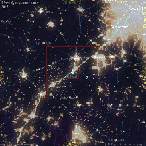
Analysis of Bāwal night lights 2016
Square area 10x10 km:
 4.92%
4.92%90-99
7.58%80-89
5.3%70-79
2.27%60-69
1.52%50-59
2.08%40-49
4.73%30-39
4.36%20-29
11.36%10-19
29.73%0-9
26.14%Square area 50x50 km:
1.51%90-99
2.25%80-89
2.52%70-79
0.8%60-69
1.17%50-59
2.03%40-49
2.69%30-39
3.48%20-29
5.52%10-19
12.94%0-9
65.08%Clear (daylight) street map image can be seen on geolist.org.
Map coordinates:
28° 41' 25.6" North, 75° 52' 48" East
28° 4' 18.6" North, 76° 34' 59.2" East
27° 26' 58.7" North, 77° 17' 10.5" East
Some cities around Bāwal sort by population:
• Rewāri
14.6 km =9.1 mi,  13°
13°
• Bhiwadi
31.3 km =19.4 mi,  60°
60°
• Dhāruhera
25.7 km =16 mi,  54°
54°
• Tijāra
30.8 km =19.1 mi,  119°
119°
• Pataudi
34.1 km =21.2 mi,  34°
34°
• Mandāwar
23.4 km =14.5 mi,  188°
188°
• Kishangarh
31.6 km =19.6 mi,  152°
152°
• Ateli Mandi
31.9 km =19.8 mi,  275°
275°
1276666 (p: 13,318)
Sources (retrieved 2019-11-25):
» Earth at Night: Flat Maps 2012, 2016