Ateli Mandi night lights from space
Night Light of Ateli Mandi (Haryana) from space (India) Src. Average luminocity for 10x10km area is 7.089% and for 50x50km: 10.1696%.
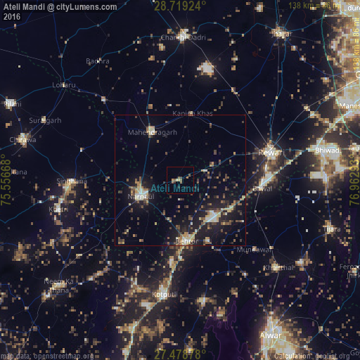
Analysis of Ateli Mandi night lights 2016
Square area 10x10 km:
 0%
0%90-99
0%80-89
1.14%70-79
1.14%60-69
1.33%50-59
3.41%40-49
0.95%30-39
0.76%20-29
1.89%10-19
0%0-9
89.39%Square area 50x50 km:
0.54%90-99
1.05%80-89
1.62%70-79
0.77%60-69
1.11%50-59
1.93%40-49
1.83%30-39
2.19%20-29
2.85%10-19
9.35%0-9
76.75%Clear (daylight) street map image can be seen on geolist.org.
Map coordinates:
28° 43' 9.3" North, 75° 33' 24" East
28° 6' 2.9" North, 76° 15' 35.3" East
27° 28' 43.6" North, 76° 57' 46.5" East
Some cities around Ateli Mandi sort by population:
• Rewāri
36.8 km =22.9 mi,  72°
72°
• Nārnaul
16.1 km =10 mi,  247°
247°
• Kotputli
44.7 km =27.8 mi,  187°
187°
• Behror
23.7 km =14.7 mi,  174°
174°
• Mahendragarh
21.5 km =13.4 mi,  330°
330°
• Bāwal
31.9 km =19.8 mi,  95°
95°
• Mandāwar
38.8 km =24.1 mi,  132°
132°
• Kanīna Khās
26.1 km =16.2 mi,  11°
11°
1278223 (p: 6,176)
Sources (retrieved 2019-11-25):
» Earth at Night: Flat Maps 2012, 2016