Pataudi night lights from space
Night Light of Pataudi (Haryana) from space (India) Src. Average luminocity for 10x10km area is 22.9484% and for 50x50km: 31.1309%.
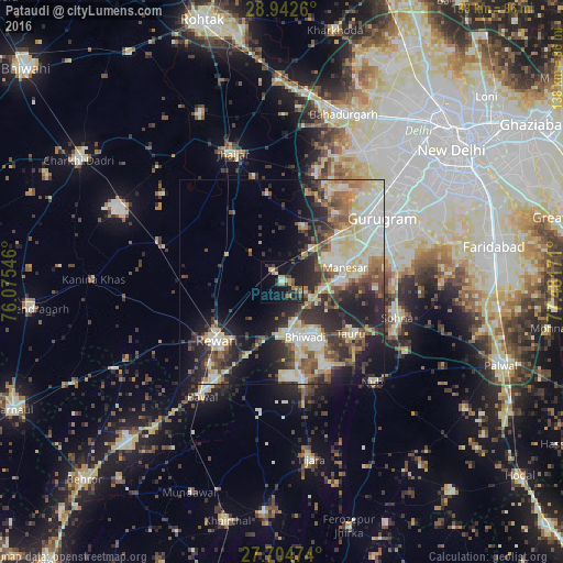
Analysis of Pataudi night lights 2016
Square area 10x10 km:
 0.4%
0.4%90-99
1.98%80-89
4.17%70-79
3.77%60-69
3.17%50-59
1.39%40-49
4.37%30-39
5.75%20-29
4.56%10-19
34.72%0-9
35.71%Square area 50x50 km:
4.44%90-99
6.63%80-89
6.27%70-79
2.7%60-69
3.26%50-59
4.17%40-49
4.8%30-39
5.44%20-29
8.76%10-19
12.77%0-9
40.76%Clear (daylight) street map image can be seen on geolist.org.
Map coordinates:
28° 56' 33.4" North, 76° 4' 31.7" East
28° 19' 31.7" North, 76° 46' 42.9" East
27° 42' 17.1" North, 77° 28' 54.2" East
Some cities around Pataudi sort by population:
• Gurgaon
28.5 km =17.7 mi,  58°
58°
• Rewāri
21.1 km =13.1 mi,  228°
228°
• Bhiwadi
15.1 km =9.4 mi,  147°
147°
• Sohna
29.4 km =18.3 mi,  107°
107°
• Dhāruhera
13.5 km =8.4 mi,  172°
172°
• Tāoru
21 km =13 mi,  127°
127°
• Nūh
33 km =20.5 mi,  138°
138°
• Farrukhnagar
14.3 km =8.9 mi,  18°
18°
1260156 (p: 18,248)
Sources (retrieved 2019-11-25):
» Earth at Night: Flat Maps 2012, 2016