Gyānpur night lights from space
Night Light of Gyānpur (Uttar Pradesh) from space (India) Src. Average luminocity for 10x10km area is 59.4266% and for 50x50km: 36.8776%.
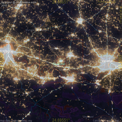
Analysis of Gyānpur night lights 2016
Square area 10x10 km:
 5.16%
5.16%90-99
8.33%80-89
6.35%70-79
10.52%60-69
11.31%50-59
15.67%40-49
25.4%30-39
14.68%20-29
2.58%10-19
0%0-9
0%Square area 50x50 km:
3.42%90-99
4.49%80-89
3.05%70-79
4.77%60-69
5.33%50-59
6.45%40-49
10.24%30-39
12.15%20-29
16.89%10-19
16.32%0-9
16.88%Clear (daylight) street map image can be seen on geolist.org.
Map coordinates:
25° 57' 59.4" North, 81° 45' 47.7" East
25° 19' 57.6" North, 82° 27' 58.9" East
24° 41' 43.8" North, 83° 10' 10.2" East
Some cities around Gyānpur sort by population:
• Mirzāpur
23.1 km =14.4 mi,  154°
154°
• Bhadohi
12.5 km =7.8 mi,  56°
56°
• Mariāhu
33.2 km =20.6 mi,  24°
24°
• Suriānwān
15.3 km =9.5 mi,  342°
342°
• Handiā
28.3 km =17.6 mi,  277°
277°
• Kachhwa
28.6 km =17.8 mi,  119°
119°
• Sirsā
38.4 km =23.9 mi,  258°
258°
• Barāgaon
36.8 km =22.9 mi,  73°
73°
1270576 (p: 13,466)
Sources (retrieved 2019-11-25):
» Earth at Night: Flat Maps 2012, 2016