Handiā night lights from space
Night Light of Handiā (Uttar Pradesh) from space (India) Src. Average luminocity for 10x10km area is 53.2421% and for 50x50km: 43.2181%.
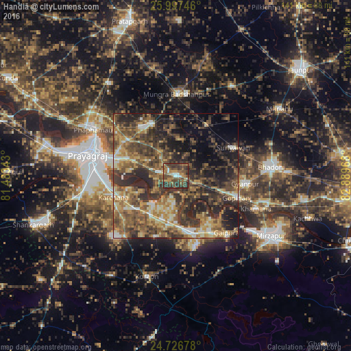
Analysis of Handiā night lights 2016
Square area 10x10 km:
 4.17%
4.17%90-99
4.17%80-89
2.78%70-79
7.94%60-69
14.68%50-59
15.48%40-49
22.42%30-39
18.65%20-29
9.72%10-19
0%0-9
0%Square area 50x50 km:
2.27%90-99
4.74%80-89
5.41%70-79
7.19%60-69
8.7%50-59
9.83%40-49
11.6%30-39
12.83%20-29
14.83%10-19
12.27%0-9
10.33%Clear (daylight) street map image can be seen on geolist.org.
Map coordinates:
25° 59' 50.9" North, 81° 29' 0.3" East
25° 21' 49.6" North, 82° 11' 11.6" East
24° 43' 36.4" North, 82° 53' 22.8" East
Some cities around Handiā sort by population:
• Allahābād
35.6 km =22.1 mi,  284°
284°
• Bhadohi
38.7 km =24 mi,  84°
84°
• Machhlīshahr
42.3 km =26.3 mi,  32°
32°
• Phulpur
22.8 km =14.2 mi,  334°
334°
• Suriānwān
25.9 km =16.1 mi,  64°
64°
• Jhūsi
29.4 km =18.3 mi,  286°
286°
• Gyānpur
28.3 km =17.6 mi,  97°
97°
• Sirsā
14.7 km =9.1 mi,  220°
220°
1270437 (p: 17,861)
Sources (retrieved 2019-11-25):
» Earth at Night: Flat Maps 2012, 2016