Kachhwa night lights from space
Night Light of Kachhwa (Uttar Pradesh) from space (India) Src. Average luminocity for 10x10km area is 29.8611% and for 50x50km: 37.2649%.
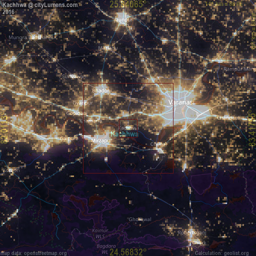
Analysis of Kachhwa night lights 2016
Square area 10x10 km:
 0.99%
0.99%90-99
1.39%80-89
0%70-79
4.17%60-69
4.96%50-59
2.78%40-49
10.91%30-39
17.66%20-29
15.08%10-19
30.75%0-9
11.31%Square area 50x50 km:
5.65%90-99
5.48%80-89
3.05%70-79
4.79%60-69
5.76%50-59
6.9%40-49
8.87%30-39
10.19%20-29
12.73%10-19
11.17%0-9
25.4%Clear (daylight) street map image can be seen on geolist.org.
Map coordinates:
25° 50' 26.3" North, 82° 0' 40.7" East
25° 12' 22.1" North, 82° 42' 51.9" East
24° 34' 6" North, 83° 25' 3.2" East
Some cities around Kachhwa sort by population:
• Varanasi
32.2 km =20 mi,  67°
67°
• Mirzāpur
16.5 km =10.3 mi,  245°
245°
• Bhadohi
25.5 km =15.8 mi,  325°
325°
• Rāmnagar
32.5 km =20.2 mi,  77°
77°
• Chunār
19 km =11.8 mi,  117°
117°
• Ahraura
38.4 km =23.9 mi, 123°
• Gyānpur
28.6 km =17.8 mi,  299°
299°
• Barāgaon
26.9 km =16.7 mi,  22°
22°
1268722 (p: 15,381)
Sources (retrieved 2019-11-25):
» Earth at Night: Flat Maps 2012, 2016