Gokavaram night lights from space
Night Light of Gokavaram (Andhra Pradesh) from space (India) Src. Average luminocity for 10x10km area is 6.8719% and for 50x50km: 7.6453%.
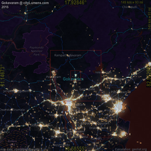
Analysis of Gokavaram night lights 2016
Square area 10x10 km:
 0%
0%90-99
0.83%80-89
0.83%70-79
0%60-69
1.03%50-59
1.24%40-49
3.51%30-39
0%20-29
3.31%10-19
0.83%0-9
88.43%Square area 50x50 km:
0.04%90-99
0.97%80-89
0.86%70-79
0.58%60-69
0.8%50-59
1.71%40-49
1.79%30-39
1.73%20-29
2.82%10-19
5.84%0-9
82.85%Clear (daylight) street map image can be seen on geolist.org.
Map coordinates:
17° 55' 42.5" North, 81° 8' 48.2" East
17° 15' 29.6" North, 81° 50' 59.5" East
16° 35' 8" North, 82° 33' 10.7" East
Some cities around Gokavaram sort by population:
• Rājahmundry
29.2 km =18.1 mi,  195°
195°
• Sāmalkot
41.3 km =25.7 mi,  122°
122°
• Peddāpuram
36.7 km =22.8 mi, 123°
• Nidadavole
43.5 km =27 mi,  205°
205°
• Polavaram
21.9 km =13.6 mi,  266°
266°
• Kovvūr
29.8 km =18.5 mi, 205°
• Rampachodavaram
21.8 km =13.5 mi,  338°
338°
• vadlamuru
38.1 km =23.7 mi, 118°
1271062 (p: 16,389)
Sources (retrieved 2019-11-25):
» Earth at Night: Flat Maps 2012, 2016