vadlamuru night lights from space
Night Light of vadlamuru (Andhra Pradesh) from space (India) Src. Average luminocity for 10x10km area is 33.5736% and for 50x50km: 18.1938%.
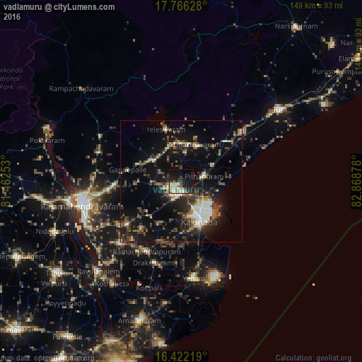
Analysis of vadlamuru night lights 2016
Square area 10x10 km:
 1.73%
1.73%90-99
10.39%80-89
5.63%70-79
2.16%60-69
4.55%50-59
2.16%40-49
2.16%30-39
5.41%20-29
12.34%10-19
32.68%0-9
20.78%Square area 50x50 km:
1.01%90-99
3.36%80-89
1.59%70-79
1.33%60-69
2.06%50-59
3.1%40-49
3.3%30-39
4.44%20-29
6.31%10-19
16.08%0-9
57.43%Clear (daylight) street map image can be seen on geolist.org.
Map coordinates:
17° 45' 58.6" North, 81° 27' 45.1" East
17° 5' 43.6" North, 82° 9' 56.3" East
16° 25' 19.9" North, 82° 52' 7.6" East
Some cities around vadlamuru sort by population:
• Kākināda
16.9 km =10.5 mi,  152°
152°
• Sāmalkot
4.5 km =2.8 mi,  165°
165°
• Pithāpuram
9.6 km =6 mi,  75°
75°
• Mandapeta
36.1 km =22.4 mi,  224°
224°
• Peddāpuram
3.6 km =2.2 mi,  234°
234°
• Rāmachandrapuram
32.3 km =20.1 mi,  206°
206°
• Ramanayyapeta
18.4 km =11.4 mi,  155°
155°
• Gokavaram
38.1 km =23.7 mi,  298°
298°
7180617 (p: 10,000)
Sources (retrieved 2019-11-25):
» Earth at Night: Flat Maps 2012, 2016