Dūdhi night lights from space
Night Light of Dūdhi (Uttar Pradesh) from space (India) Src. Average luminocity for 10x10km area is 10.9792% and for 50x50km: 2.8929%.
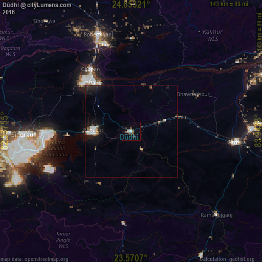
Analysis of Dūdhi night lights 2016
Square area 10x10 km:
 2.08%
2.08%90-99
1.7%80-89
0.76%70-79
0.76%60-69
0.76%50-59
1.7%40-49
0.76%30-39
3.6%20-29
0.76%10-19
5.11%0-9
82.01%Square area 50x50 km:
0.53%90-99
0.51%80-89
0.08%70-79
0.17%60-69
0.2%50-59
0.39%40-49
0.28%30-39
0.38%20-29
1.03%10-19
2.83%0-9
93.6%Clear (daylight) street map image can be seen on geolist.org.
Map coordinates:
24° 51' 11.6" North, 82° 32' 15.2" East
24° 12' 48.9" North, 83° 14' 26.4" East
23° 34' 14.5" North, 83° 56' 37.7" East
Some cities around Dūdhi sort by population:
• Singrauli
57.4 km =35.7 mi,  268°
268°
• Renukūt
20.8 km =12.9 mi, 270°
• Obra
34.3 km =21.3 mi,  311°
311°
• Garhwa
57.8 km =35.9 mi,  95°
95°
• Robertsganj
55.6 km =34.5 mi,  341°
341°
• Kota
28.2 km =17.5 mi, 336°
• Chopan
40.5 km =25.2 mi,  327°
327°
• Rāmānuj Ganj
65 km =40.4 mi,  134°
134°
1272302 (p: 12,742)
Sources (retrieved 2019-11-25):
» Earth at Night: Flat Maps 2012, 2016