Chopan night lights from space
Night Light of Chopan (Uttar Pradesh) from space (India) Src. Average luminocity for 10x10km area is 34.9603% and for 50x50km: 8.6519%.
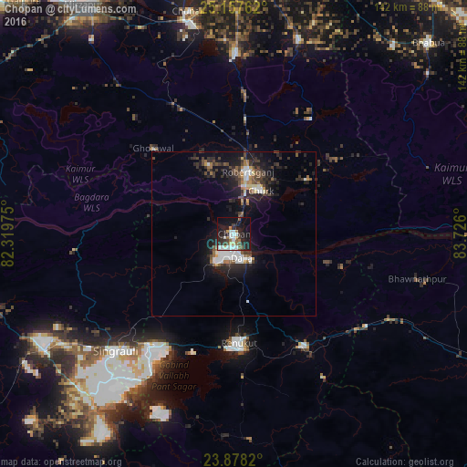
Analysis of Chopan night lights 2016
Square area 10x10 km:
 7.54%
7.54%90-99
7.14%80-89
2.38%70-79
0.79%60-69
4.56%50-59
4.56%40-49
2.58%30-39
6.94%20-29
14.09%10-19
28.97%0-9
20.44%Square area 50x50 km:
1.43%90-99
1.36%80-89
0.48%70-79
0.54%60-69
0.88%50-59
1.14%40-49
1.5%30-39
1.86%20-29
3.19%10-19
7.8%0-9
79.82%Clear (daylight) street map image can be seen on geolist.org.
Map coordinates:
25° 9' 27.4" North, 82° 19' 11.1" East
24° 31' 10.3" North, 83° 1' 22.3" East
23° 52' 41.5" North, 83° 43' 33.6" East
Some cities around Chopan sort by population:
• Singrauli
50 km =31.1 mi,  224°
224°
• Renukūt
33.7 km =20.9 mi,  177°
177°
• Obra
11.8 km =7.3 mi,  197°
197°
• Robertsganj
19.3 km =12 mi,  13°
13°
• Ahraura
55.2 km =34.3 mi,  1°
1°
• Kota
13.6 km =8.5 mi,  126°
126°
• Dūdhi
40.5 km =25.2 mi,  147°
147°
• Ghorāwal
35.9 km =22.3 mi,  316°
316°
1273993 (p: 13,585)
Sources (retrieved 2019-11-25):
» Earth at Night: Flat Maps 2012, 2016