Doda night lights from space
Night Light of Doda (Jammu and Kashmir) from space (India) Src. Average luminocity for 10x10km area is 3.5916% and for 50x50km: 2.8312%.
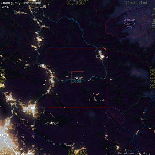
Analysis of Doda night lights 2016
Square area 10x10 km:
 0%
0%90-99
0%80-89
0%70-79
0.73%60-69
0.73%50-59
2.01%40-49
1.65%30-39
0.73%20-29
0.73%10-19
0%0-9
93.41%Square area 50x50 km:
0.17%90-99
0.31%80-89
0.16%70-79
0.4%60-69
0.33%50-59
0.61%40-49
0.77%30-39
0.53%20-29
0.63%10-19
2.23%0-9
93.86%Clear (daylight) street map image can be seen on geolist.org.
Map coordinates:
33° 44' 9.1" North, 74° 50' 39.6" East
33° 8' 57" North, 75° 32' 50.9" East
32° 33' 30.6" North, 76° 15' 2.1" East
Some cities around Doda sort by population:
• Udhampur
45.8 km =28.5 mi,  236°
236°
• Kishtwār
27.4 km =17 mi,  48°
48°
• Bhadarwāh
24.6 km =15.3 mi,  140°
140°
• Katra
60 km =37.3 mi,  253°
253°
• Rāmnagar
43.9 km =27.3 mi,  210°
210°
• Riāsi
67 km =41.6 mi,  263°
263°
• Rāmban
30.9 km =19.2 mi,  289°
289°
• Qāzigund
66.1 km =41.1 mi,  325°
325°
1272476 (p: 17,748)
Sources (retrieved 2019-11-25):
» Earth at Night: Flat Maps 2012, 2016