Riāsi night lights from space
Night Light of Riāsi (Jammu and Kashmir) from space (India) Src. Average luminocity for 10x10km area is 23.2821% and for 50x50km: 11.4262%.
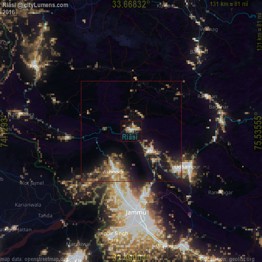
Analysis of Riāsi night lights 2016
Square area 10x10 km:
 2.38%
2.38%90-99
3.66%80-89
3.66%70-79
2.93%60-69
2.75%50-59
2.2%40-49
4.03%30-39
2.2%20-29
3.85%10-19
26.92%0-9
45.42%Square area 50x50 km:
0.67%90-99
1.42%80-89
1.07%70-79
1.2%60-69
1.81%50-59
2.51%40-49
2.73%30-39
2.52%20-29
3.27%10-19
9.25%0-9
73.55%Clear (daylight) street map image can be seen on geolist.org.
Map coordinates:
33° 40' 6" North, 74° 7' 45.5" East
33° 4' 52.1" North, 74° 49' 56.7" East
32° 29' 24.1" North, 75° 32' 8" East
Some cities around Riāsi sort by population:
• Jammu
38.6 km =24 mi,  174°
174°
• Udhampur
33.2 km =20.6 mi,  121°
121°
• Nawānshahr
45.2 km =28.1 mi,  218°
218°
• Akhnūr
25.6 km =15.9 mi,  201°
201°
• Bishnāh
52.4 km =32.6 mi,  177°
177°
• Katra
13.6 km =8.5 mi,  137°
137°
• Rāmban
41.6 km =25.8 mi,  64°
64°
• Khaur
53.2 km =33.1 mi, 182°
1258167 (p: 8,101)
Sources (retrieved 2019-11-25):
» Earth at Night: Flat Maps 2012, 2016