Rāmnagar night lights from space
Night Light of Rāmnagar (Jammu and Kashmir) from space (India) Src. Average luminocity for 10x10km area is 5.1871% and for 50x50km: 7.1618%.
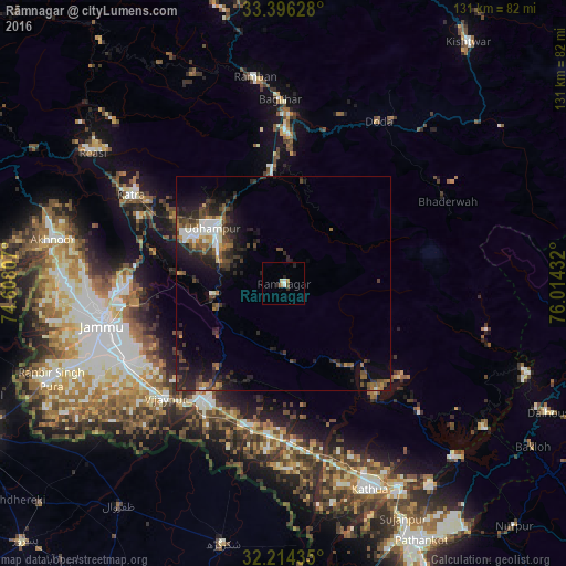
Analysis of Rāmnagar night lights 2016
Square area 10x10 km:
 0.7%
0.7%90-99
1.22%80-89
0.17%70-79
0.7%60-69
0.7%50-59
0%40-49
0.7%30-39
1.05%20-29
2.1%10-19
0.7%0-9
91.96%Square area 50x50 km:
0.59%90-99
1.27%80-89
0.26%70-79
0.62%60-69
0.84%50-59
1.06%40-49
1.69%30-39
1.76%20-29
3.44%10-19
4.82%0-9
83.65%Clear (daylight) street map image can be seen on geolist.org.
Map coordinates:
33° 23' 46.6" North, 74° 36' 29.1" East
32° 48' 26.2" North, 75° 18' 40.3" East
32° 12' 51.7" North, 76° 0' 51.6" East
Some cities around Rāmnagar sort by population:
• Jammu
42.1 km =26.2 mi,  259°
259°
• Udhampur
20.9 km =13 mi,  308°
308°
• Sāmba
32.6 km =20.3 mi,  213°
213°
• Doda
43.9 km =27.3 mi,  30°
30°
• Bhadarwāh
42.5 km =26.4 mi,  63°
63°
• Bishnāh
47.9 km =29.8 mi,  242°
242°
• Hirānagar
39.4 km =24.5 mi,  185°
185°
• Katra
40.9 km =25.4 mi,  300°
300°
1258635 (p: 8,166)
Sources (retrieved 2019-11-25):
» Earth at Night: Flat Maps 2012, 2016