Katra night lights from space
Night Light of Katra (Jammu and Kashmir) from space (India) Src. Average luminocity for 10x10km area is 38.4524% and for 50x50km: 20.5189%.
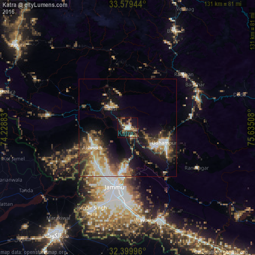
Analysis of Katra night lights 2016
Square area 10x10 km:
 2.56%
2.56%90-99
7.69%80-89
2.93%70-79
3.11%60-69
9.16%50-59
6.78%40-49
8.79%30-39
8.42%20-29
8.24%10-19
32.23%0-9
10.07%Square area 50x50 km:
1.92%90-99
4.33%80-89
2.2%70-79
2.61%60-69
2.9%50-59
3.48%40-49
4.01%30-39
3.52%20-29
5.12%10-19
11.36%0-9
58.56%Clear (daylight) street map image can be seen on geolist.org.
Map coordinates:
33° 34' 46" North, 74° 13' 43.8" East
32° 59' 30" North, 74° 55' 55" East
32° 23' 59.9" North, 75° 38' 6.3" East
Some cities around Katra sort by population:
• Jammu
29.1 km =18.1 mi,  191°
191°
• Udhampur
20.4 km =12.7 mi,  111°
111°
• Akhnūr
23.2 km =14.4 mi,  233°
233°
• Bishnāh
43 km =26.7 mi, 189°
• Rāmnagar
40.9 km =25.4 mi,  120°
120°
• Riāsi
13.6 km =8.5 mi,  317°
317°
• Rāmban
39.7 km =24.7 mi,  45°
45°
• Khaur
44.7 km =27.8 mi, 194°
1267448 (p: 9,106)
Sources (retrieved 2019-11-25):
» Earth at Night: Flat Maps 2012, 2016