Rāmban night lights from space
Night Light of Rāmban (Jammu and Kashmir) from space (India) Src. Average luminocity for 10x10km area is 12.6783% and for 50x50km: 4.1645%.
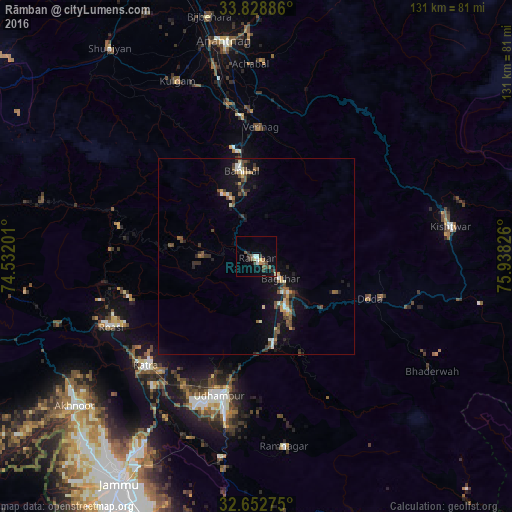
Analysis of Rāmban night lights 2016
Square area 10x10 km:
 1.22%
1.22%90-99
1.92%80-89
1.4%70-79
0.87%60-69
1.05%50-59
1.92%40-49
2.62%30-39
3.5%20-29
2.27%10-19
2.8%0-9
80.42%Square area 50x50 km:
0.23%90-99
0.53%80-89
0.43%70-79
0.32%60-69
0.39%50-59
0.83%40-49
0.85%30-39
0.99%20-29
0.85%10-19
3.6%0-9
90.97%Clear (daylight) street map image can be seen on geolist.org.
Map coordinates:
33° 49' 43.9" North, 74° 31' 55.2" East
33° 14' 34" North, 75° 14' 6.5" East
32° 39' 9.9" North, 75° 56' 17.7" East
Some cities around Rāmban sort by population:
• Udhampur
36.6 km =22.7 mi,  194°
194°
• Kishtwār
50.1 km =31.1 mi,  80°
80°
• Doda
30.9 km =19.2 mi,  109°
109°
• Kulgam
49 km =30.4 mi,  335°
335°
• Katra
39.7 km =24.7 mi,  225°
225°
• Rāmnagar
48.9 km =30.4 mi,  171°
171°
• Riāsi
41.6 km =25.8 mi,  244°
244°
• Qāzigund
44.8 km =27.8 mi,  348°
348°
1258715 (p: 7,317)
Sources (retrieved 2019-11-25):
» Earth at Night: Flat Maps 2012, 2016