Dhārūr night lights from space
Night Light of Dhārūr (Maharashtra) from space (India) Src. Average luminocity for 10x10km area is 4.9329% and for 50x50km: 2.4411%.
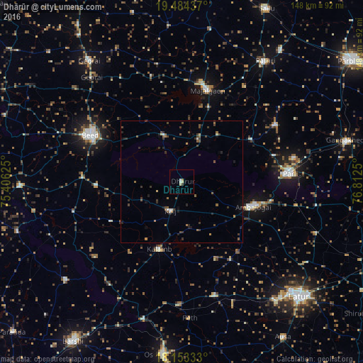
Analysis of Dhārūr night lights 2016
Square area 10x10 km:
 0.65%
0.65%90-99
1.08%80-89
1.73%70-79
0%60-69
0.87%50-59
0%40-49
0.22%30-39
0.65%20-29
0%10-19
0%0-9
94.81%Square area 50x50 km:
0.08%90-99
0.2%80-89
0.18%70-79
0.17%60-69
0.34%50-59
0.57%40-49
0.65%30-39
0.76%20-29
0.77%10-19
0.46%0-9
95.82%Clear (daylight) street map image can be seen on geolist.org.
Map coordinates:
19° 29' 3.7" North, 75° 24' 22.5" East
18° 49' 12.6" North, 76° 6' 33.7" East
18° 9' 12" North, 76° 48' 45" East
Some cities around Dhārūr sort by population:
• Parli Vaijnāth
44.6 km =27.7 mi,  85°
85°
• Ambājogāi
30.7 km =19.1 mi,  108°
108°
• Mājalgaon
39.2 km =24.4 mi,  15°
15°
• Pāthri
59.5 km =37 mi,  34°
34°
• Mānwat
67.3 km =41.8 mi,  37°
37°
• Gevrai
62.1 km =38.6 mi,  322°
322°
• Bhūm
62.2 km =38.6 mi,  229°
229°
• Ashti
63.1 km =39.2 mi,  11°
11°
1272819 (p: 19,060)
Sources (retrieved 2019-11-25):
» Earth at Night: Flat Maps 2012, 2016