Bhūm night lights from space
Night Light of Bhūm (Maharashtra) from space (India) Src. Average luminocity for 10x10km area is 7.2417% and for 50x50km: 4.7624%.
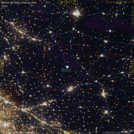
Analysis of Bhūm night lights 2016
Square area 10x10 km:
 0.83%
0.83%90-99
1.65%80-89
1.65%70-79
0%60-69
0.83%50-59
0.83%40-49
2.07%30-39
0.41%20-29
0%10-19
0%0-9
91.74%Square area 50x50 km:
0.25%90-99
0.49%80-89
0.51%70-79
0.32%60-69
0.72%50-59
1.05%40-49
0.75%30-39
1.43%20-29
1.35%10-19
1.84%0-9
91.29%Clear (daylight) street map image can be seen on geolist.org.
Map coordinates:
19° 7' 29" North, 74° 57' 20.3" East
18° 27' 32.7" North, 75° 39' 31.6" East
17° 47' 27.1" North, 76° 21' 42.8" East
Some cities around Bhūm sort by population:
• Bārsi
25.2 km =15.7 mi,  171°
171°
• Osmanabad
50.6 km =31.4 mi,  127°
127°
• Ambājogāi
82.5 km =51.3 mi,  68°
68°
• Tuljāpur
66.3 km =41.2 mi,  139°
139°
• Kurduvādi
48.1 km =29.9 mi,  212°
212°
• Karmāla
49.4 km =30.7 mi,  263°
263°
• Dhārūr
62.2 km =38.6 mi,  49°
49°
• Kāti
60.4 km =37.5 mi,  156°
156°
1275804 (p: 18,543)
Sources (retrieved 2019-11-25):
» Earth at Night: Flat Maps 2012, 2016