Dalhousie night lights from space
Night Light of Dalhousie (Himachal Pradesh) from space (India) Src. Average luminocity for 10x10km area is 11.4038% and for 50x50km: 3.3109%.
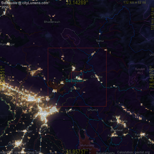
Analysis of Dalhousie night lights 2016
Square area 10x10 km:
 0.7%
0.7%90-99
2.27%80-89
1.75%70-79
0.17%60-69
1.75%50-59
1.22%40-49
1.92%30-39
1.4%20-29
0.7%10-19
0.87%0-9
87.24%Square area 50x50 km:
0.26%90-99
0.54%80-89
0.25%70-79
0.23%60-69
0.43%50-59
0.48%40-49
0.64%30-39
0.55%20-29
1.03%10-19
1.37%0-9
94.21%Clear (daylight) street map image can be seen on geolist.org.
Map coordinates:
33° 8' 34.4" North, 75° 14' 36.6" East
32° 33' 7.9" North, 75° 56' 47.9" East
31° 57' 27.3" North, 76° 38' 59.1" East
Some cities around Dalhousie sort by population:
• Pathānkot
41.4 km =25.7 mi,  221°
221°
• Kathua
44.4 km =27.6 mi,  242°
242°
• Chamba
16.9 km =10.5 mi,  88°
88°
• Dharamsala
50.9 km =31.6 mi,  136°
136°
• Bhadarwāh
52.1 km =32.4 mi,  335°
335°
• Yol
49.1 km =30.5 mi,  151°
151°
• Parol
53.3 km =33.1 mi, 244°
• Nagrota
56.7 km =35.2 mi,  166°
166°
1273648 (p: 7,601)
Sources (retrieved 2019-11-25):
» Earth at Night: Flat Maps 2012, 2016