Parol night lights from space
Night Light of Parol (Jammu and Kashmir) from space (India) Src. Average luminocity for 10x10km area is 37.0989% and for 50x50km: 23.6556%.
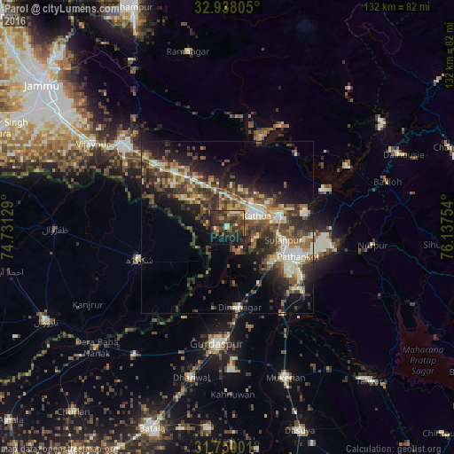
Analysis of Parol night lights 2016
Square area 10x10 km:
 0.92%
0.92%90-99
5.68%80-89
1.28%70-79
3.3%60-69
6.96%50-59
6.78%40-49
11.54%30-39
17.77%20-29
17.03%10-19
22.53%0-9
6.23%Square area 50x50 km:
1.73%90-99
4.4%80-89
2.25%70-79
2.75%60-69
2.91%50-59
4.5%40-49
6.54%30-39
5.81%20-29
8.24%10-19
10.91%0-9
49.95%Clear (daylight) street map image can be seen on geolist.org.
Map coordinates:
32° 56' 17" North, 74° 43' 52.6" East
32° 20' 45.5" North, 75° 26' 3.9" East
31° 45' 0" North, 76° 8' 15.1" East
Some cities around Parol sort by population:
• Pathānkot
22 km =13.7 mi,  111°
111°
• Shakargarh, PK
27.4 km =17 mi,  250°
250°
• Kathua
8.9 km =5.5 mi,  73°
73°
• Fazilpur, PK
39.5 km =24.5 mi,  241°
241°
• Sāmba
38.1 km =23.7 mi,  309°
309°
• Dīnānagar
23.6 km =14.7 mi,  171°
171°
• Dhāriwāl
44.6 km =27.7 mi,  193°
193°
• Hirānagar
19.5 km =12.1 mi, 308°
1260275 (p: 7,800)
Sources (retrieved 2019-11-25):
» Earth at Night: Flat Maps 2012, 2016