Yol night lights from space
Night Light of Yol (Himachal Pradesh) from space (India) Src. Average luminocity for 10x10km area is 0.3164% and for 50x50km: 2.5613%.
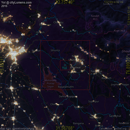
Analysis of Yol night lights 2016
Square area 10x10 km:
 0%
0%90-99
0%80-89
0%70-79
0%60-69
0%50-59
0%40-49
0%30-39
0%20-29
0.35%10-19
0%0-9
99.65%Square area 50x50 km:
0.08%90-99
0.2%80-89
0.3%70-79
0.18%60-69
0.58%50-59
0.41%40-49
0.58%30-39
0.59%20-29
0.52%10-19
1.38%0-9
95.2%Clear (daylight) street map image can be seen on geolist.org.
Map coordinates:
32° 45' 27" North, 75° 29' 35.2" East
32° 9' 51.2" North, 76° 11' 46.4" East
31° 34' 1.5" North, 76° 53' 57.7" East
Some cities around Yol sort by population:
• Talwāra
38.6 km =24 mi,  229°
229°
• Chamba
44 km =27.3 mi,  351°
351°
• Dharamsala
13.2 km =8.2 mi,  61°
61°
• Kāngar
10.2 km =6.3 mi,  142°
142°
• Tīra Sujānpur
46.9 km =29.1 mi, 141°
• Nagrota
15.5 km =9.6 mi,  219°
219°
• Hājipur
46.5 km =28.9 mi,  243°
243°
• Jawāla Mukhi
34.3 km =21.3 mi,  160°
160°
1252714 (p: 11,314)
Sources (retrieved 2019-11-25):
» Earth at Night: Flat Maps 2012, 2016