Chamba night lights from space
Night Light of Chamba (Himachal Pradesh) from space (India) Src. Average luminocity for 10x10km area is 8.3497% and for 50x50km: 1.8215%.
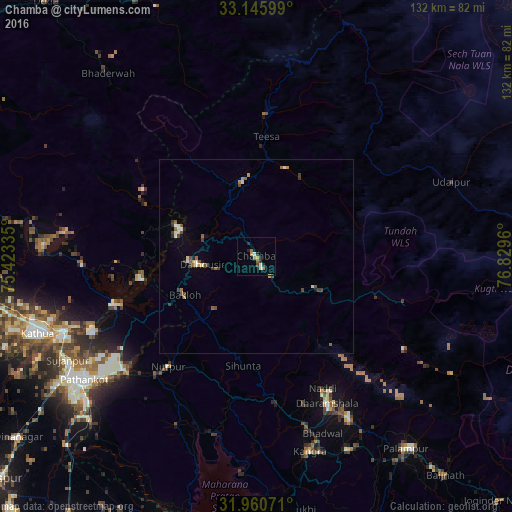

Analysis of Chamba night lights 2016
Square area 10x10 km:
 0.7%
0.7%90-99
1.4%80-89
0.35%70-79
1.57%60-69
1.92%50-59
0.7%40-49
1.05%30-39
0.7%20-29
3.5%10-19
0.7%0-9
87.41%Square area 50x50 km:
0.19%90-99
0.28%80-89
0.13%70-79
0.15%60-69
0.32%50-59
0.28%40-49
0.38%30-39
0.35%20-29
0.26%10-19
0.12%0-9
97.53%Clear (daylight) street map image can be seen on geolist.org.
Map coordinates:
33° 8' 45.6" North, 75° 25' 24.1" East
32° 33' 19.1" North, 76° 7' 35.3" East
31° 57' 38.6" North, 76° 49' 46.6" East
Some cities around Chamba sort by population:
• Pathānkot
54.3 km =33.7 mi,  234°
234°
• Kathua
60.1 km =37.3 mi,  249°
249°
• Dharamsala
41.5 km =25.8 mi,  153°
153°
• Bhadarwāh
60.7 km =37.7 mi,  320°
320°
• Yol
44 km =27.3 mi,  171°
171°
• Kāngar
53.2 km =33.1 mi, 166°
• Dalhousie
16.9 km =10.5 mi,  268°
268°
• Nagrota
55.5 km =34.5 mi,  183°
183°
1274848 (p: 21,502)
Sources (retrieved 2019-11-25):
» Earth at Night: Flat Maps 2012, 2016