Nagrota night lights from space
Night Light of Nagrota (Himachal Pradesh) from space (India) Src. Average luminocity for 10x10km area is 0.5909% and for 50x50km: 2.2419%.
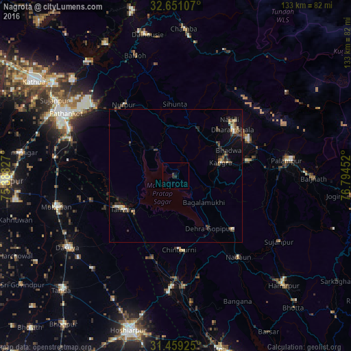
Analysis of Nagrota night lights 2016
Square area 10x10 km:
 0%
0%90-99
0%80-89
0%70-79
0%60-69
0%50-59
0%40-49
0%30-39
0.7%20-29
1.4%10-19
0%0-9
97.9%Square area 50x50 km:
0.12%90-99
0.26%80-89
0.27%70-79
0.16%60-69
0.21%50-59
0.3%40-49
0.54%30-39
0.62%20-29
0.69%10-19
1.02%0-9
95.8%Clear (daylight) street map image can be seen on geolist.org.
Map coordinates:
32° 39' 3.9" North, 75° 23' 17.8" East
32° 3' 25.6" North, 76° 5' 29" East
31° 27' 33.3" North, 76° 47' 40.3" East
Some cities around Nagrota sort by population:
• Talwāra
23.4 km =14.5 mi,  235°
235°
• Mukeriān
46.2 km =28.7 mi,  255°
255°
• Dharamsala
28.1 km =17.5 mi,  49°
49°
• Yol
15.5 km =9.6 mi,  39°
39°
• Kāngar
16.6 km =10.3 mi,  76°
76°
• Tīra Sujānpur
46.3 km =28.8 mi,  122°
122°
• Hājipur
33 km =20.5 mi,  254°
254°
• Jawāla Mukhi
29.6 km =18.4 mi,  133°
133°
1262162 (p: 6,125)
Sources (retrieved 2019-11-25):
» Earth at Night: Flat Maps 2012, 2016