Ghorāwal night lights from space
Night Light of Ghorāwal (Uttar Pradesh) from space (India) Src. Average luminocity for 10x10km area is 3.339% and for 50x50km: 1.7661%.
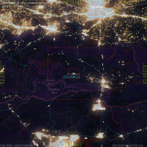
Analysis of Ghorāwal night lights 2016
Square area 10x10 km:
 0.19%
0.19%90-99
0.57%80-89
0%70-79
0%60-69
0%50-59
1.52%40-49
1.52%30-39
0.19%20-29
2.08%10-19
0.76%0-9
93.18%Square area 50x50 km:
0.02%90-99
0.04%80-89
0%70-79
0.03%60-69
0.24%50-59
0.23%40-49
0.55%30-39
0.69%20-29
0.96%10-19
2.33%0-9
94.91%Clear (daylight) street map image can be seen on geolist.org.
Map coordinates:
25° 23' 29.2" North, 82° 4' 35.5" East
24° 45' 16.5" North, 82° 46' 46.7" East
24° 6' 52" North, 83° 28' 58" East
Some cities around Ghorāwal sort by population:
• Mirzāpur
48.5 km =30.1 mi,  333°
333°
• Obra
42.9 km =26.7 mi,  150°
150°
• Robertsganj
30 km =18.6 mi,  104°
104°
• Chunār
42.8 km =26.6 mi,  13°
13°
• Ahraura
38.7 km =24 mi,  41°
41°
• Kachhwa
50.6 km =31.4 mi,  352°
352°
• Kota
49.3 km =30.6 mi,  133°
133°
• Chopan
35.9 km =22.3 mi,  136°
136°
1271264 (p: 7,492)
Sources (retrieved 2019-11-25):
» Earth at Night: Flat Maps 2012, 2016