Chīma night lights from space
Night Light of Chīma (Punjab) from space (India) Src. Average luminocity for 10x10km area is 8.7815% and for 50x50km: 26.795%.
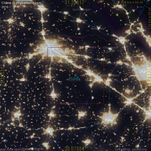
Analysis of Chīma night lights 2016
Square area 10x10 km:
 0.17%
0.17%90-99
0.52%80-89
0%70-79
1.4%60-69
0.87%50-59
0.35%40-49
1.75%30-39
1.22%20-29
5.07%10-19
14.16%0-9
74.48%Square area 50x50 km:
3.92%90-99
5.04%80-89
3.49%70-79
2.2%60-69
3.17%50-59
4.14%40-49
4.73%30-39
5%20-29
7.91%10-19
16.28%0-9
44.11%Clear (daylight) street map image can be seen on geolist.org.
Map coordinates:
31° 17' 17.4" North, 75° 22' 59.9" East
30° 41' 7.4" North, 76° 5' 11.1" East
30° 4' 43.8" North, 76° 47' 22.4" East
Some cities around Chīma sort by population:
• Khanna
13.1 km =8.1 mi,  80°
80°
• Māler Kotla
26.2 km =16.3 mi,  229°
229°
• Sirhind
28.9 km =18 mi,  99°
99°
• Dorāha
14 km =8.7 mi,  334°
334°
• Māchhīwāra
27.8 km =17.3 mi,  22°
22°
• Samrāla
19.6 km =12.2 mi,  31°
31°
• Amloh
16.3 km =10.1 mi,  121°
121°
• Khamānon Kalān
29.5 km =18.3 mi,  60°
60°
1436610 (p: 9,894)
Sources (retrieved 2019-11-25):
» Earth at Night: Flat Maps 2012, 2016