Samrāla night lights from space
Night Light of Samrāla (Punjab) from space (India) Src. Average luminocity for 10x10km area is 27.1941% and for 50x50km: 22.8567%.
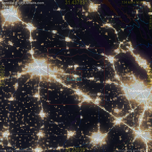
Analysis of Samrāla night lights 2016
Square area 10x10 km:
 2.27%
2.27%90-99
1.92%80-89
2.1%70-79
2.27%60-69
3.32%50-59
5.24%40-49
5.07%30-39
6.99%20-29
8.92%10-19
43.88%0-9
18.01%Square area 50x50 km:
1.76%90-99
4.18%80-89
3.24%70-79
1.95%60-69
2.63%50-59
4.04%40-49
4.93%30-39
4.75%20-29
7.51%10-19
13.11%0-9
51.9%Clear (daylight) street map image can be seen on geolist.org.
Map coordinates:
31° 26' 16.2" North, 75° 29' 24.4" East
30° 50' 9.6" North, 76° 11' 35.7" East
30° 13' 49.4" North, 76° 53' 46.9" East
Some cities around Samrāla sort by population:
• Khanna
14.8 km =9.2 mi,  169°
169°
• Dorāha
16.7 km =10.4 mi,  255°
255°
• Māchhīwāra
8.9 km =5.5 mi,  4°
4°
• Basi
25.8 km =16 mi,  129°
129°
• Amloh
25.6 km =15.9 mi, 171°
• Rāhon
25.1 km =15.6 mi,  343°
343°
• Chīma
19.6 km =12.2 mi,  211°
211°
• Khamānon Kalān
15.6 km =9.7 mi,  97°
97°
1257503 (p: 18,623)
Sources (retrieved 2019-11-25):
» Earth at Night: Flat Maps 2012, 2016