Amloh night lights from space
Night Light of Amloh (Punjab) from space (India) Src. Average luminocity for 10x10km area is 28.965% and for 50x50km: 17.8795%.
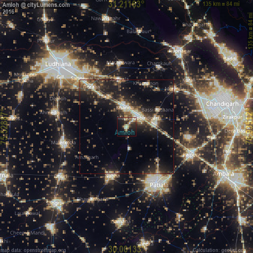
Analysis of Amloh night lights 2016
Square area 10x10 km:
 1.57%
1.57%90-99
5.94%80-89
3.67%70-79
3.32%60-69
2.62%50-59
5.07%40-49
4.55%30-39
4.9%20-29
12.94%10-19
23.43%0-9
31.99%Square area 50x50 km:
1.04%90-99
2.65%80-89
2.32%70-79
1.49%60-69
1.69%50-59
2.98%40-49
4.2%30-39
4.25%20-29
7.13%10-19
13.83%0-9
58.41%Clear (daylight) street map image can be seen on geolist.org.
Map coordinates:
31° 12' 41.9" North, 75° 31' 43.9" East
30° 36' 30.1" North, 76° 13' 55.2" East
30° 0' 4.8" North, 76° 56' 6.4" East
Some cities around Amloh sort by population:
• Khanna
10.8 km =6.7 mi,  354°
354°
• Nābha
26.9 km =16.7 mi,  196°
196°
• Sirhind
15.1 km =9.4 mi,  75°
75°
• Dorāha
29.1 km =18.1 mi,  316°
316°
• Samrāla
25.6 km =15.9 mi, 351°
• Basi
18.5 km =11.5 mi,  61°
61°
• Chīma
16.3 km =10.1 mi,  301°
301°
• Khamānon Kalān
26 km =16.2 mi,  26°
26°
1278758 (p: 13,859)
Sources (retrieved 2019-11-25):
» Earth at Night: Flat Maps 2012, 2016