Chānasma night lights from space
Night Light of Chānasma (Gujarat) from space (India) Src. Average luminocity for 10x10km area is 3.1964% and for 50x50km: 5.1575%.
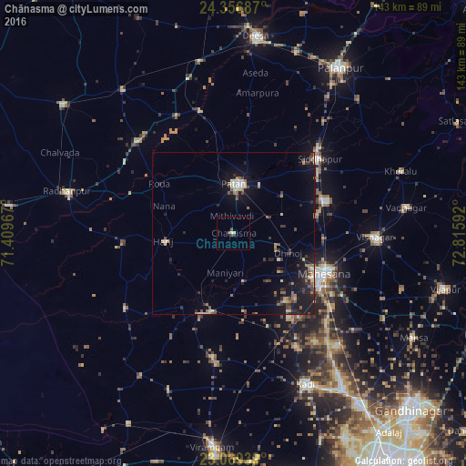
Analysis of Chānasma night lights 2016
Square area 10x10 km:
100  0%
0%
90-99 0.79%
80-89 0.79%
70-79 0%
60-69 0%
50-59 0.2%
40-49 2.18%
30-39 0.4%
20-29 0.4%
10-19 0%
0-9 95.24%
0%90-99
0.79%80-89
0.79%70-79
0%60-69
0%50-59
0.2%40-49
2.18%30-39
0.4%20-29
0.4%10-19
0%0-9
95.24%Square area 50x50 km:
100 0.16%
90-99 0.63%
80-89 0.62%
70-79 0.45%
60-69 0.74%
50-59 0.85%
40-49 0.78%
30-39 1.01%
20-29 1.58%
10-19 5.16%
0-9 88.04%
0.16%90-99
0.63%80-89
0.62%70-79
0.45%60-69
0.74%50-59
0.85%40-49
0.78%30-39
1.01%20-29
1.58%10-19
5.16%0-9
88.04%Clear (daylight) street map image can be seen on geolist.org.
Map coordinates:
24° 21' 24.7" North, 71° 24' 34.8" East
23° 42' 53" North, 72° 6' 46" East
23° 4' 9.8" North, 72° 48' 57.3" East
Some cities around Chānasma sort by population:
• Pātan
15.2 km =9.4 mi,  6°
6°
• Visnagar
44.8 km =27.8 mi,  92°
92°
• Unjha
30 km =18.6 mi,  70°
70°
• Siddhapur
34.7 km =21.6 mi,  49°
49°
• Un
39.8 km =24.7 mi,  298°
298°
• Hārij
21.1 km =13.1 mi,  263°
263°
• Māndal
51.3 km =31.9 mi,  202°
202°
• Kānodar
50.5 km =31.4 mi,  34°
34°
1274807 (p: 15,572)
Sources (retrieved 2019-11-25):
» Earth at Night: Flat Maps 2012, 2016