Māndal night lights from space
Night Light of Māndal (Gujarat) from space (India) Src. Average luminocity for 10x10km area is 3.3902% and for 50x50km: 4.6819%.
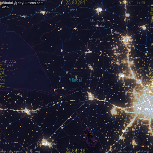
Analysis of Māndal night lights 2016
Square area 10x10 km:
 0%
0%90-99
0%80-89
0.76%70-79
1.52%60-69
0%50-59
0%40-49
0.76%30-39
0.76%20-29
1.52%10-19
0%0-9
94.7%Square area 50x50 km:
0.11%90-99
0.44%80-89
0.56%70-79
0.6%60-69
0.75%50-59
1.18%40-49
1.12%30-39
0.84%20-29
0.72%10-19
2.42%0-9
91.24%Clear (daylight) street map image can be seen on geolist.org.
Map coordinates:
23° 55' 58.5" North, 71° 12' 55.5" East
23° 17' 19.1" North, 71° 55' 6.7" East
22° 38' 28.5" North, 72° 37' 18" East
Some cities around Māndal sort by population:
• Pātan
66.1 km =41.1 mi,  18°
18°
• Dhrāngadhra
56.7 km =35.2 mi,  234°
234°
• Kadi
42.4 km =26.3 mi,  88°
88°
• Sānand
57.7 km =35.9 mi,  124°
124°
• Hārij
45 km =28 mi,  358°
358°
• Chānasma
51.3 km =31.9 mi, 22°
• Lakhtar
49.8 km =30.9 mi,  195°
195°
• Jhulasan
56.8 km =35.3 mi, 85°
1263918 (p: 13,345)
Sources (retrieved 2019-11-25):
» Earth at Night: Flat Maps 2012, 2016