Burhar night lights from space
Night Light of Burhar (Madhya Pradesh) from space (India) Src. Average luminocity for 10x10km area is 54.4413% and for 50x50km: 11.7057%.
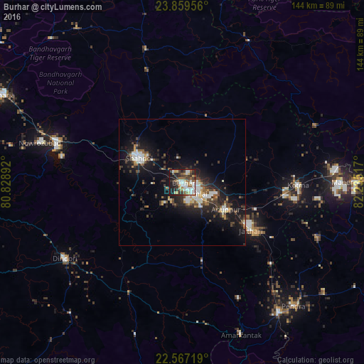
Analysis of Burhar night lights 2016
Square area 10x10 km:
 10.61%
90-99
13.64%80-89
7.01%70-79
4.17%60-69
4.92%50-59
9.66%40-49
7.01%30-39
12.31%20-29
14.39%10-19
16.1%0-9
0.19%Square area 50x50 km:
1.69%90-99
2.1%80-89
0.84%70-79
1.15%60-69
0.78%50-59
1.65%40-49
1.99%30-39
2.45%20-29
3.99%10-19
10.29%0-9
73.06%Clear (daylight) street map image can be seen on geolist.org.
Map coordinates:
23° 51' 34.4" North, 80° 49' 44.1" East
23° 12' 53.8" North, 81° 31' 55.3" East
22° 34' 1.9" North, 82° 14' 6.6" East
Some cities around Burhar sort by population:
• Shahdol
19.5 km =12.1 mi,  296°
296°
• Kotma
45.7 km =28.4 mi,  91°
91°
• Pāli
52.6 km =32.7 mi,  288°
288°
• Dindori
55.4 km =34.4 mi,  236°
236°
• Anūppur
20.4 km =12.7 mi,  127°
127°
• Bodri
11.6 km =7.2 mi, 241°
• Shāhpur
58 km =36 mi,  248°
248°
• Jaisinghnagar
54.3 km =33.7 mi,  344°
344°
1275066 (p: 18,191)
Sources (retrieved 2019-11-25):
» Earth at Night: Flat Maps 2012, 2016