Anūppur night lights from space
Night Light of Anūppur (Madhya Pradesh) from space (India) Src. Average luminocity for 10x10km area is 29.9602% and for 50x50km: 11.3997%.
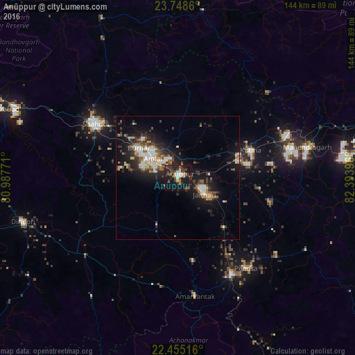
Analysis of Anūppur night lights 2016
Square area 10x10 km:
 2.46%
2.46%90-99
3.03%80-89
3.03%70-79
2.84%60-69
2.27%50-59
3.79%40-49
7.95%30-39
11.55%20-29
13.64%10-19
34.28%0-9
15.15%Square area 50x50 km:
1.59%90-99
1.94%80-89
0.92%70-79
1.11%60-69
1.11%50-59
1.69%40-49
1.67%30-39
2.44%20-29
3.7%10-19
9.66%0-9
74.18%Clear (daylight) street map image can be seen on geolist.org.
Map coordinates:
23° 44' 55" North, 80° 59' 15.8" East
23° 6' 12.4" North, 81° 41' 27" East
22° 27' 18.6" North, 82° 23' 38.3" East
Some cities around Anūppur sort by population:
• Shahdol
39.7 km =24.7 mi,  302°
302°
• Kotma
31.5 km =19.6 mi,  69°
69°
• Pasān
59.4 km =36.9 mi,  119°
119°
• Burhar
20.4 km =12.7 mi,  307°
307°
• Gaurela
44.4 km =27.6 mi,  150°
150°
• Bodri
27.3 km =17 mi,  284°
284°
• Pendra
45.7 km =28.4 mi,  142°
142°
• Amarkantak
48.2 km =30 mi,  171°
171°
1278508 (p: 18,122)
Sources (retrieved 2019-11-25):
» Earth at Night: Flat Maps 2012, 2016