Bilthra night lights from space
Night Light of Bilthra (Uttar Pradesh) from space (India) Src. Average luminocity for 10x10km area is 27.0198% and for 50x50km: 26.1419%.
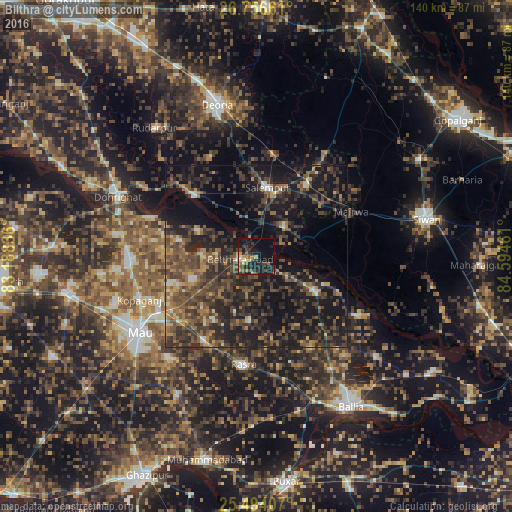
Analysis of Bilthra night lights 2016
Square area 10x10 km:
 0.79%
0.79%90-99
3.57%80-89
1.79%70-79
2.78%60-69
3.77%50-59
6.35%40-49
3.57%30-39
9.33%20-29
9.52%10-19
32.54%0-9
25.99%Square area 50x50 km:
0.68%90-99
1.33%80-89
1.48%70-79
2.69%60-69
4%50-59
6.13%40-49
8.91%30-39
10.02%20-29
12.73%10-19
23.27%0-9
28.75%Clear (daylight) street map image can be seen on geolist.org.
Map coordinates:
26° 45' 23.8" North, 83° 11' 18.1" East
26° 7' 37.4" North, 83° 53' 29.3" East
25° 29' 38.7" North, 84° 35' 40.6" East
Some cities around Bilthra sort by population:
• Mau
38.9 km =24.2 mi,  238°
238°
• Ghosī
35.2 km =21.9 mi,  266°
266°
• Kopāganj
34.6 km =21.5 mi,  249°
249°
• Rasrā
30.2 km =18.8 mi,  186°
186°
• Lar
11.5 km =7.1 mi,  42°
42°
• Sikandarpur
18.6 km =11.6 mi,  120°
120°
• Maniar
32.2 km =20 mi, 119°
• Mairwa
29.6 km =18.4 mi,  66°
66°
1275589 (p: 17,228)
Sources (retrieved 2019-11-25):
» Earth at Night: Flat Maps 2012, 2016