Bīghāpur Khurd night lights from space
Night Light of Bīghāpur Khurd (Uttar Pradesh) from space (India) Src. Average luminocity for 10x10km area is 7.7614% and for 50x50km: 12.5562%.
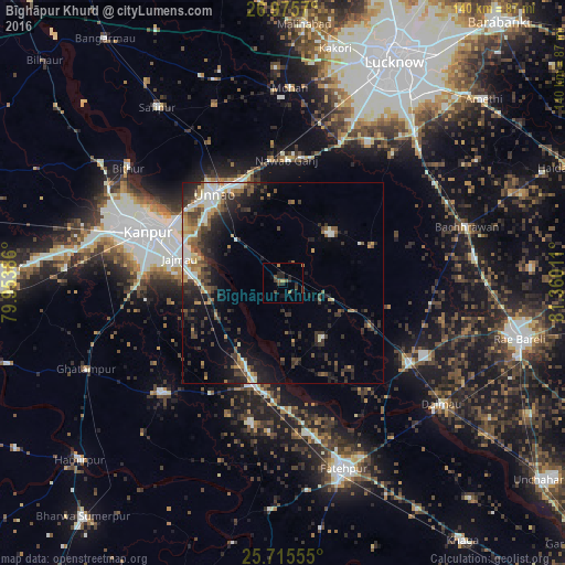
Analysis of Bīghāpur Khurd night lights 2016
Square area 10x10 km:
 0%
0%90-99
0%80-89
0.19%70-79
0.95%60-69
1.7%50-59
1.89%40-49
2.84%30-39
1.52%20-29
5.87%10-19
2.27%0-9
82.77%Square area 50x50 km:
1.13%90-99
2.37%80-89
0.98%70-79
1.57%60-69
1.31%50-59
1.66%40-49
2.51%30-39
3.18%20-29
4.31%10-19
7.04%0-9
73.94%Clear (daylight) street map image can be seen on geolist.org.
Map coordinates:
26° 58' 32.5" North, 79° 57' 13.9" East
26° 20' 50.4" North, 80° 39' 25.1" East
25° 42' 56" North, 81° 21' 36.4" East
Some cities around Bīghāpur Khurd sort by population:
• Kanpur
33.3 km =20.7 mi,  293°
293°
• Unnāo
27.9 km =17.3 mi,  322°
322°
• Bindki
35.5 km =22.1 mi,  193°
193°
• Jagdīshpur
46.1 km =28.6 mi,  346°
346°
• Purwā
16.9 km =10.5 mi,  43°
43°
• Maurānwān
24 km =14.9 mi,  67°
67°
• Nawābganj
38.4 km =23.9 mi,  295°
295°
• Bhagwantnagar
17 km =10.6 mi,  143°
143°
1275722 (p: 6,409)
Sources (retrieved 2019-11-25):
» Earth at Night: Flat Maps 2012, 2016