Nawābganj night lights from space
Night Light of Nawābganj (Uttar Pradesh) from space (India) Src. Average luminocity for 10x10km area is 87.3409% and for 50x50km: 28.8594%.
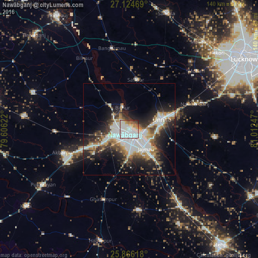
Analysis of Nawābganj night lights 2016
Square area 10x10 km:
 40.91%
90-99
32.01%80-89
4.73%70-79
3.03%60-69
4.73%50-59
4.92%40-49
4.73%30-39
2.27%20-29
2.65%10-19
0%0-9
0%Square area 50x50 km:
6.33%90-99
8.33%80-89
2.09%70-79
2.57%60-69
3.12%50-59
2.84%40-49
3.82%30-39
4.27%20-29
7.45%10-19
11.16%0-9
48.02%Clear (daylight) street map image can be seen on geolist.org.
Map coordinates:
27° 7' 28.9" North, 79° 36' 22.4" East
26° 29' 49.8" North, 80° 18' 33.6" East
25° 51' 58.2" North, 81° 0' 44.9" East
Some cities around Nawābganj sort by population:
• Kanpur
5.4 km =3.4 mi,  131°
131°
• Unnāo
18.6 km =11.6 mi,  72°
72°
• Jagdīshpur
36.6 km =22.7 mi,  39°
39°
• Safīpur
27 km =16.8 mi,  7°
7°
• Bithūr
12.8 km =8 mi,  342°
342°
• Rasūlābād
32.9 km =20.4 mi,  33°
33°
• Ugu
33.3 km =20.7 mi,  1°
1°
• Fatehpur Chaurāsi
32.8 km =20.4 mi,  352°
352°
1261638 (p: 10,758)
Sources (retrieved 2019-11-25):
» Earth at Night: Flat Maps 2012, 2016