Bhagwantnagar night lights from space
Night Light of Bhagwantnagar (Uttar Pradesh) from space (India) Src. Average luminocity for 10x10km area is 9.1329% and for 50x50km: 10.517%.
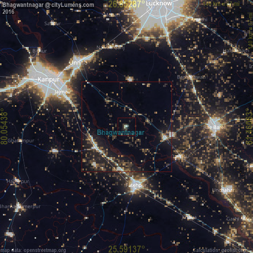
Analysis of Bhagwantnagar night lights 2016
Square area 10x10 km:
 0.2%
0.2%90-99
1.39%80-89
0.79%70-79
0%60-69
0%50-59
0%40-49
2.18%30-39
6.75%20-29
2.58%10-19
4.17%0-9
81.94%Square area 50x50 km:
0.54%90-99
0.93%80-89
0.5%70-79
1.28%60-69
1.17%50-59
1.65%40-49
2.3%30-39
3.39%20-29
4.65%10-19
9.86%0-9
73.73%Clear (daylight) street map image can be seen on geolist.org.
Map coordinates:
26° 51' 10.3" North, 80° 3' 15.8" East
26° 13' 25.8" North, 80° 45' 27" East
25° 35' 28.9" North, 81° 27' 38.3" East
Some cities around Bhagwantnagar sort by population:
• Fatehpur
33.4 km =20.8 mi,  170°
170°
• Unnāo
44.9 km =27.9 mi,  323°
323°
• Bindki
27.6 km =17.1 mi,  220°
220°
• Purwā
26 km =16.2 mi,  3°
3°
• Maurānwān
25.9 km =16.1 mi,  28°
28°
• Dalmau
32.4 km =20.1 mi,  123°
123°
• Bahua
44.8 km =27.8 mi,  197°
197°
• Bīghāpur Khurd
17 km =10.6 mi, 323°
1276275 (p: 6,596)
Sources (retrieved 2019-11-25):
» Earth at Night: Flat Maps 2012, 2016