Bahua night lights from space
Night Light of Bahua (Uttar Pradesh) from space (India) Src. Average luminocity for 10x10km area is 4.5398% and for 50x50km: 9.4356%.
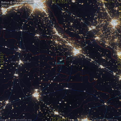
Analysis of Bahua night lights 2016
Square area 10x10 km:
 0.38%
0.38%90-99
0.38%80-89
0.76%70-79
0%60-69
0.76%50-59
0.19%40-49
0.57%30-39
1.52%20-29
1.7%10-19
3.79%0-9
89.96%Square area 50x50 km:
0.86%90-99
1.34%80-89
0.63%70-79
0.78%60-69
1.05%50-59
1.34%40-49
2.61%30-39
2.82%20-29
4.1%10-19
6.82%0-9
77.64%Clear (daylight) street map image can be seen on geolist.org.
Map coordinates:
26° 28' 13.9" North, 79° 55' 9.9" East
25° 50' 21.9" North, 80° 37' 21.2" East
25° 12' 17.7" North, 81° 19' 32.4" East
Some cities around Bahua sort by population:
• Fatehpur
21.4 km =13.3 mi,  62°
62°
• Bindki
22.4 km =13.9 mi,  348°
348°
• Baberu
33.5 km =20.8 mi,  165°
165°
• Dalmau
47.8 km =29.7 mi, 58°
• Bisenda Buzurg
48.5 km =30.1 mi,  180°
180°
• Tindwāri
26.5 km =16.5 mi,  201°
201°
• Bhagwantnagar
44.8 km =27.8 mi,  17°
17°
• Kishanpur
45.7 km =28.4 mi,  118°
118°
1277793 (p: 10,243)
Sources (retrieved 2019-11-25):
» Earth at Night: Flat Maps 2012, 2016