Dalmau night lights from space
Night Light of Dalmau (Uttar Pradesh) from space (India) Src. Average luminocity for 10x10km area is 26.1448% and for 50x50km: 20.1122%.
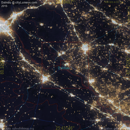
Analysis of Dalmau night lights 2016
Square area 10x10 km:
 1.98%
1.98%90-99
3.57%80-89
0.79%70-79
4.37%60-69
5.56%50-59
3.37%40-49
5.36%30-39
7.54%20-29
6.15%10-19
20.63%0-9
40.67%Square area 50x50 km:
1.8%90-99
2.31%80-89
1.11%70-79
1.61%60-69
1.9%50-59
3.36%40-49
5.19%30-39
6.73%20-29
9.44%10-19
19.12%0-9
47.42%Clear (daylight) street map image can be seen on geolist.org.
Map coordinates:
26° 41' 40.8" North, 80° 19' 36" East
26° 3' 53.2" North, 81° 1' 47.3" East
25° 25' 53.3" North, 81° 43' 58.5" East
Some cities around Dalmau sort by population:
• Raebareli
27.4 km =17 mi,  47°
47°
• Fatehpur
26.5 km =16.5 mi,  234°
234°
• Bindki
45.4 km =28.2 mi,  265°
265°
• Maurānwān
43.1 km =26.8 mi,  339°
339°
• Salon
42.6 km =26.5 mi,  95°
95°
• Khāga
33.4 km =20.8 mi,  167°
167°
• Bhagwantnagar
32.4 km =20.1 mi,  303°
303°
• Mahārājganj
42.8 km =26.6 mi,  34°
34°
1273637 (p: 11,432)
Sources (retrieved 2019-11-25):
» Earth at Night: Flat Maps 2012, 2016