Purushottampur night lights from space
Night Light of Purushottampur (Odisha) from space (India) Src. Average luminocity for 10x10km area is 9.2955% and for 50x50km: 13.597%.
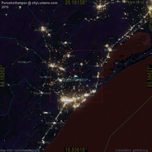
Analysis of Purushottampur night lights 2016
Square area 10x10 km:
 0.62%
0.62%90-99
1.03%80-89
1.65%70-79
0%60-69
0%50-59
0.83%40-49
3.31%30-39
4.34%20-29
2.48%10-19
1.65%0-9
84.09%Square area 50x50 km:
1.06%90-99
2.04%80-89
0.9%70-79
1.1%60-69
1.13%50-59
2.8%40-49
3.24%30-39
3.61%20-29
4.78%10-19
8.91%0-9
70.42%Clear (daylight) street map image can be seen on geolist.org.
Map coordinates:
20° 10' 53.7" North, 84° 10' 55.3" East
19° 31' 12.9" North, 84° 53' 6.5" East
18° 51' 22.2" North, 85° 35' 17.8" East
Some cities around Purushottampur sort by population:
• Brahmapur
25.1 km =15.6 mi,  202°
202°
• Hinjilikatu
15.3 km =9.5 mi,  253°
253°
• Chatrapur
21 km =13 mi,  150°
150°
• Polasara
20.7 km =12.9 mi,  338°
338°
• Kodala
12.9 km =8 mi,  26°
26°
• Khallikot
23.3 km =14.5 mi,  64°
64°
• Ganjām
22.8 km =14.2 mi,  130°
130°
• Rambha
22.5 km =14 mi,  91°
91°
1259158 (p: 14,707)
Sources (retrieved 2019-11-25):
» Earth at Night: Flat Maps 2012, 2016