Amarkantak night lights from space
Night Light of Amarkantak (Madhya Pradesh) from space (India) Src. Average luminocity for 10x10km area is 4.1528% and for 50x50km: 3.0642%.
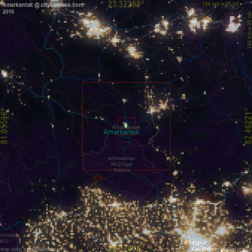
Analysis of Amarkantak night lights 2016
Square area 10x10 km:
 0.4%
0.4%90-99
0.4%80-89
0.79%70-79
0.4%60-69
1.19%50-59
0%40-49
1.59%30-39
0.6%20-29
0.99%10-19
0%0-9
93.65%Square area 50x50 km:
0.19%90-99
0.35%80-89
0.06%70-79
0.27%60-69
0.51%50-59
0.49%40-49
0.86%30-39
0.87%20-29
1.03%10-19
2.56%0-9
92.81%Clear (daylight) street map image can be seen on geolist.org.
Map coordinates:
23° 19' 19.5" North, 81° 3' 21.5" East
22° 40' 29.5" North, 81° 45' 32.7" East
22° 1' 28.4" North, 82° 27' 44" East
Some cities around Amarkantak sort by population:
• Pasān
48.8 km =30.3 mi,  67°
67°
• Ratanpur
60.3 km =37.5 mi,  135°
135°
• Anūppur
48.2 km =30 mi,  351°
351°
• Kotā
50.2 km =31.2 mi,  147°
147°
• Gaurela
17 km =10.6 mi,  58°
58°
• Pandaria
61.6 km =38.3 mi,  215°
215°
• Lormi
44.9 km =27.9 mi,  187°
187°
• Pendra
23.4 km =14.5 mi, 61°
1278905 (p: 7,613)
Sources (retrieved 2019-11-25):
» Earth at Night: Flat Maps 2012, 2016