Pendra night lights from space
Night Light of Pendra (Chhattisgarh) from space (India) Src. Average luminocity for 10x10km area is 27.621% and for 50x50km: 3.5833%.
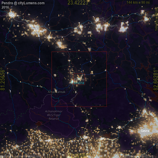
Analysis of Pendra night lights 2016
Square area 10x10 km:
 0.79%
0.79%90-99
2.98%80-89
0.2%70-79
3.97%60-69
8.73%50-59
3.77%40-49
5.16%30-39
6.15%20-29
8.93%10-19
38.49%0-9
20.83%Square area 50x50 km:
0.21%90-99
0.38%80-89
0.13%70-79
0.3%60-69
0.44%50-59
0.59%40-49
0.93%30-39
1.1%20-29
1.33%10-19
2.88%0-9
91.72%Clear (daylight) street map image can be seen on geolist.org.
Map coordinates:
23° 25' 20" North, 81° 15' 23.6" East
22° 46' 31.7" North, 81° 57' 34.8" East
22° 7' 32.3" North, 82° 39' 46.1" East
Some cities around Pendra sort by population:
• Kotma
47.7 km =29.6 mi,  2°
2°
• Pasān
25.6 km =15.9 mi,  72°
72°
• Ratanpur
58.4 km =36.3 mi,  158°
158°
• Anūppur
45.7 km =28.4 mi,  322°
322°
• Kotā
53.8 km =33.4 mi,  172°
172°
• Gaurela
6.4 km =4 mi,  248°
248°
• Lormi
61.7 km =38.3 mi,  205°
205°
• Amarkantak
23.4 km =14.5 mi,  241°
241°
1259924 (p: 12,637)
Sources (retrieved 2019-11-25):
» Earth at Night: Flat Maps 2012, 2016