Ambāgarh Chauki night lights from space
Night Light of Ambāgarh Chauki (Chhattisgarh) from space (India) Src. Average luminocity for 10x10km area is 2.7083% and for 50x50km: 0.8885%.
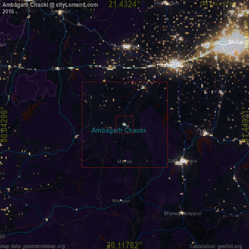
Analysis of Ambāgarh Chauki night lights 2016
Square area 10x10 km:
 0.57%
0.57%90-99
0.19%80-89
0%70-79
0.57%60-69
0.19%50-59
0.76%40-49
0%30-39
1.33%20-29
0.95%10-19
0%0-9
95.45%Square area 50x50 km:
0.02%90-99
0.04%80-89
0.03%70-79
0.07%60-69
0.14%50-59
0.18%40-49
0.23%30-39
0.42%20-29
0.38%10-19
0.43%0-9
98.06%Clear (daylight) street map image can be seen on geolist.org.
Map coordinates:
21° 25' 56.6" North, 80° 2' 34.7" East
20° 46' 35.2" North, 80° 44' 45.9" East
20° 7' 3.4" North, 81° 26' 57.2" East
Some cities around Ambāgarh Chauki sort by population:
• Durg
71.8 km =44.6 mi,  50°
50°
• Rāj-Nāndgaon
46.2 km =28.7 mi,  39°
39°
• Dhamtari
83.8 km =52.1 mi,  95°
95°
• Dongargarh
45.9 km =28.5 mi,  1°
1°
• Balod
48.1 km =29.9 mi, 96°
• Bhānpurī
40 km =24.9 mi,  28°
28°
• Khairāgarh
75.4 km =46.9 mi,  18°
18°
• Dongargaon
24.3 km =15.1 mi, 26°
1278869 (p: 9,265)
Sources (retrieved 2019-11-25):
» Earth at Night: Flat Maps 2012, 2016