Patiāli night lights from space
Night Light of Patiāli (Uttar Pradesh) from space (India) Src. Average luminocity for 10x10km area is 4.4206% and for 50x50km: 4.4633%.
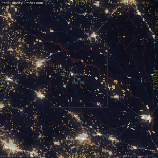
Analysis of Patiāli night lights 2016
Square area 10x10 km:
 0%
0%90-99
0.2%80-89
0.2%70-79
0%60-69
0%50-59
0.4%40-49
0.79%30-39
1.98%20-29
5.56%10-19
1.19%0-9
89.68%Square area 50x50 km:
0.11%90-99
0.46%80-89
0.51%70-79
0.85%60-69
0.43%50-59
0.43%40-49
0.92%30-39
1.14%20-29
1.29%10-19
1.01%0-9
92.85%Clear (daylight) street map image can be seen on geolist.org.
Map coordinates:
28° 18' 42" North, 78° 17' 42.4" East
27° 41' 27.1" North, 78° 59' 53.6" East
27° 3' 59.4" North, 79° 42' 4.9" East
Some cities around Patiāli sort by population:
• Ganj Dundwāra
7.3 km =4.5 mi,  309°
309°
• Kakrāla
29.6 km =18.4 mi,  40°
40°
• Alīganj
27.8 km =17.3 mi,  142°
142°
• Sahāwar
20 km =12.4 mi, 305°
• Usehat
26.4 km =16.4 mi,  63°
63°
• Sidhpura
14.2 km =8.8 mi,  243°
243°
• Amānpur
25.7 km =16 mi,  275°
275°
• Kampil
28.8 km =17.9 mi,  107°
107°
1260104 (p: 13,515)
Sources (retrieved 2019-11-25):
» Earth at Night: Flat Maps 2012, 2016