Alīpur night lights from space
Night Light of Alīpur (Delhi) from space (India) Src. Average luminocity for 10x10km area is 93.2405% and for 50x50km: 68.5995%.

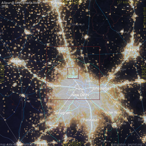
Analysis of Alīpur night lights 2016
Square area 10x10 km:
 28.03%
90-99
35.98%80-89
35.98%70-79
0%60-69
0%50-59
0%40-49
0%30-39
0%20-29
0%10-19
0%0-9
0%Square area 50x50 km:
27.64%90-99
14.53%80-89
11.94%70-79
3.99%60-69
4.4%50-59
5.24%40-49
5.66%30-39
6.41%20-29
9.76%10-19
6.38%0-9
4.05%Clear (daylight) street map image can be seen on geolist.org.
Map coordinates:
29° 24' 46.6" North, 76° 25' 48.1" East
28° 47' 55" North, 77° 7' 59.3" East
28° 10' 50.3" North, 77° 50' 10.6" East
Some cities around Alīpur sort by population:
• Rohini
8.9 km =5.5 mi,  225°
225°
• Narela
7.2 km =4.5 mi,  326°
326°
• Karol Bāgh
17.3 km =10.7 mi,  161°
161°
• Nāngloi Jāt
14.7 km =9.1 mi,  205°
205°
• Loni
16.2 km =10.1 mi,  108°
108°
• Khekra
16.5 km =10.3 mi,  63°
63°
• Bāghpat
18.3 km =11.4 mi,  27°
27°
• Bawāna
9.6 km =6 mi,  269°
269°
1279005 (p: 20,736)
Sources (retrieved 2019-11-25):
» Earth at Night: Flat Maps 2012, 2016