Akbarpur night lights from space
Night Light of Akbarpur (Uttar Pradesh) from space (India) Src. Average luminocity for 10x10km area is 58.0871% and for 50x50km: 22.017%.
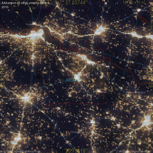

Analysis of Akbarpur night lights 2016
Square area 10x10 km:
 9.47%
9.47%90-99
14.39%80-89
7.77%70-79
8.14%60-69
8.33%50-59
6.25%40-49
10.61%30-39
11.93%20-29
12.88%10-19
9.85%0-9
0.38%Square area 50x50 km:
1.6%90-99
1.86%80-89
0.99%70-79
1.75%60-69
2.68%50-59
4.08%40-49
6.13%30-39
7.79%20-29
10.88%10-19
23.59%0-9
38.65%Clear (daylight) street map image can be seen on geolist.org.
Map coordinates:
27° 3' 26.8" North, 81° 49' 52.3" East
26° 25' 46.3" North, 82° 32' 3.5" East
25° 47' 53.4" North, 83° 14' 14.8" East
Some cities around Akbarpur sort by population:
• Bastī
43.8 km =27.2 mi,  24°
24°
• Tāndā
18.2 km =11.3 mi,  42°
42°
• Jalālpur
24.2 km =15 mi,  122°
122°
• Goshāinganj
21.9 km =13.6 mi,  315°
315°
• Dostpur
18.3 km =11.4 mi,  200°
200°
• Atraulia
42.5 km =26.4 mi,  104°
104°
• Haraiya
41.2 km =25.6 mi,  350°
350°
• Kādīpur
33.4 km =20.8 mi,  209°
209°
1279134 (p: 36,865)
Sources (retrieved 2019-11-25):
» Earth at Night: Flat Maps 2012, 2016