Goshāinganj night lights from space
Night Light of Goshāinganj (Uttar Pradesh) from space (India) Src. Average luminocity for 10x10km area is 20.6098% and for 50x50km: 26.9192%.
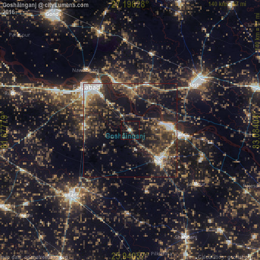
Analysis of Goshāinganj night lights 2016
Square area 10x10 km:
 1.14%
1.14%90-99
1.14%80-89
1.14%70-79
1.33%60-69
0.57%50-59
2.65%40-49
4.92%30-39
9.66%20-29
8.14%10-19
40.72%0-9
28.6%Square area 50x50 km:
2.2%90-99
2.85%80-89
1.66%70-79
2.52%60-69
3.59%50-59
4.94%40-49
7.62%30-39
9.3%20-29
12.68%10-19
19.99%0-9
32.65%Clear (daylight) street map image can be seen on geolist.org.
Map coordinates:
27° 11' 53.8" North, 81° 40' 40" East
26° 34' 16.1" North, 82° 22' 51.3" East
25° 56' 26.1" North, 83° 5' 2.5" East
Some cities around Goshāinganj sort by population:
• Fyzābād
32.3 km =20.1 mi,  314°
314°
• Tāndā
27.7 km =17.2 mi,  94°
94°
• Ajodhya
30.8 km =19.1 mi,  325°
325°
• Akbarpur
21.9 km =13.6 mi,  135°
135°
• Nawābganj
40.3 km =25 mi,  323°
323°
• Bīkāpur
24.8 km =15.4 mi,  276°
276°
• Dostpur
34.1 km =21.2 mi,  164°
164°
• Haraiya
26.2 km =16.3 mi,  18°
18°
1270895 (p: 13,176)
Sources (retrieved 2019-11-25):
» Earth at Night: Flat Maps 2012, 2016