Dostpur night lights from space
Night Light of Dostpur (Uttar Pradesh) from space (India) Src. Average luminocity for 10x10km area is 17.7242% and for 50x50km: 15.8552%.
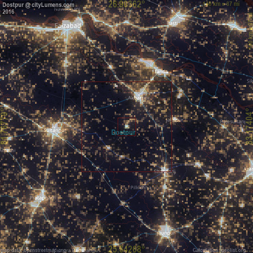
Analysis of Dostpur night lights 2016
Square area 10x10 km:
 0.79%
0.79%90-99
0.79%80-89
0.99%70-79
3.77%60-69
2.18%50-59
4.17%40-49
1.98%30-39
6.35%20-29
3.37%10-19
17.26%0-9
58.33%Square area 50x50 km:
0.57%90-99
1.15%80-89
0.66%70-79
1.26%60-69
1.79%50-59
2.84%40-49
4.31%30-39
5.99%20-29
8.25%10-19
15.58%0-9
57.61%Clear (daylight) street map image can be seen on geolist.org.
Map coordinates:
26° 54' 13" North, 81° 46' 4" East
26° 16' 29.5" North, 82° 28' 15.3" East
25° 38' 33.6" North, 83° 10' 26.5" East
Some cities around Dostpur sort by population:
• Sultānpur
39.8 km =24.7 mi,  267°
267°
• Tāndā
35.8 km =22.2 mi,  31°
31°
• Akbarpur
18.3 km =11.4 mi,  20°
20°
• Jalālpur
27 km =16.8 mi,  81°
81°
• Shāhganj
32.9 km =20.4 mi,  139°
139°
• Goshāinganj
34.1 km =21.2 mi,  344°
344°
• Phūlpur
46 km =28.6 mi,  118°
118°
• Kādīpur
15.6 km =9.7 mi,  220°
220°
1272358 (p: 12,688)
Sources (retrieved 2019-11-25):
» Earth at Night: Flat Maps 2012, 2016