Rahat night lights from space
Night Light of Rahat (Southern District) from space (Israel) Src. Average luminocity for 10x10km area is 60.4161% and for 50x50km: 36.0754%.
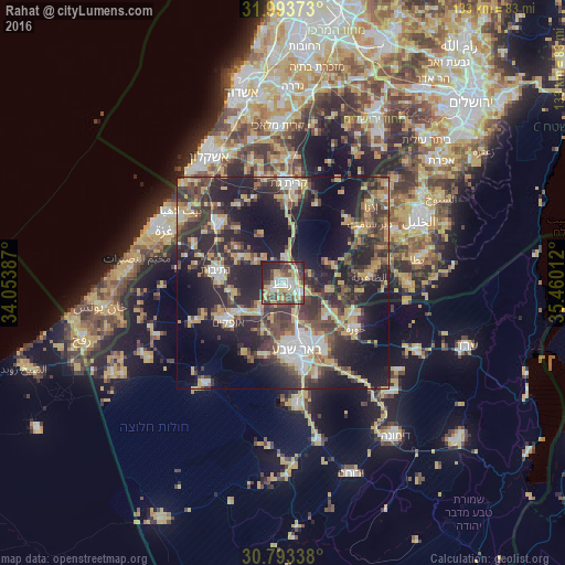
Analysis of Rahat night lights 2016
Square area 10x10 km:
 9.09%
9.09%90-99
12.06%80-89
10.14%70-79
13.46%60-69
2.1%50-59
6.99%40-49
20.1%30-39
7.34%20-29
16.61%10-19
2.1%0-9
0%Square area 50x50 km:
4.13%90-99
4.02%80-89
4.9%70-79
7.66%60-69
2.53%50-59
3.51%40-49
8.88%30-39
9.1%20-29
15.42%10-19
20.61%0-9
19.24%Clear (daylight) street map image can be seen on geolist.org.
Map coordinates:
31° 59' 37.4" North, 34° 3' 13.9" East
31° 23' 43.7" North, 34° 45' 25.2" East
30° 47' 36.2" North, 35° 27' 36.4" East
Some cities around Rahat sort by population:
• Beersheba
16.3 km =10.1 mi,  168°
168°
• Kiryat Gat
23.9 km =14.9 mi,  1°
1°
• Az̧ Z̧āhirīyah, PS
20.6 km =12.8 mi,  85°
85°
• Netivot
16.2 km =10.1 mi,  280°
280°
• Ofaqim
15.8 km =9.8 mi,  235°
235°
• Sederot
20.9 km =13 mi,  313°
313°
• Bayt ‘Awwā, PS
22.2 km =13.8 mi,  55°
55°
• Lehavim
6.2 km =3.9 mi,  114°
114°
8184212 (p: 19,586)
Sources (retrieved 2019-11-25):
» Earth at Night: Flat Maps 2012, 2016