Lehavim night lights from space
Night Light of Lehavim (Southern District) from space (Israel) Src. Average luminocity for 10x10km area is 53.3584% and for 50x50km: 36.3438%.
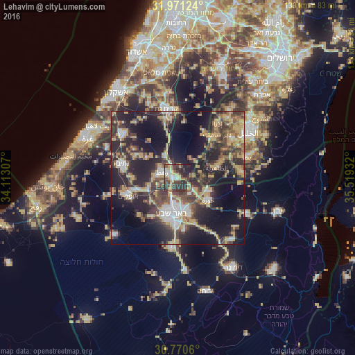
Analysis of Lehavim night lights 2016
Square area 10x10 km:
 4.72%
4.72%90-99
8.74%80-89
11.71%70-79
9.79%60-69
1.4%50-59
4.9%40-49
16.61%30-39
21.85%20-29
16.26%10-19
4.02%0-9
0%Square area 50x50 km:
3.92%90-99
3.89%80-89
5.05%70-79
8.5%60-69
2.65%50-59
3.92%40-49
8.52%30-39
8.7%20-29
14.61%10-19
21%0-9
19.25%Clear (daylight) street map image can be seen on geolist.org.
Map coordinates:
31° 58' 16.5" North, 34° 6' 47.1" East
31° 22' 22.2" North, 34° 48' 58.3" East
30° 46' 14.2" North, 35° 31' 9.6" East
Some cities around Lehavim sort by population:
• Beersheba
13.7 km =8.5 mi,  189°
189°
• Az̧ Z̧āhirīyah, PS
15.5 km =9.6 mi,  74°
74°
• Netivot
22.3 km =13.9 mi,  284°
284°
• Ofaqim
19.7 km =12.2 mi,  250°
250°
• Rahat
6.2 km =3.9 mi,  294°
294°
• As Samū‘, PS
23.9 km =14.9 mi,  83°
83°
• Bayt ‘Awwā, PS
19.7 km =12.2 mi,  39°
39°
• Dayr Sāmit, PS
22.3 km =13.9 mi, 42°
6693244 (p: 6,000)
Sources (retrieved 2019-11-25):
» Earth at Night: Flat Maps 2012, 2016