Hartstown night lights from space
Night Light of Hartstown (Leinster) from space (Ireland) Src. Average luminocity for 10x10km area is 69.4034% and for 50x50km: 25.2886%.
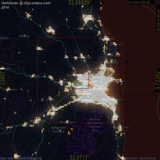
Analysis of Hartstown night lights 2016
Square area 10x10 km:
 24.87%
90-99
21.56%80-89
7.54%70-79
3.17%60-69
3.57%50-59
4.23%40-49
7.67%30-39
7.67%20-29
12.57%10-19
6.22%0-9
0.93%Square area 50x50 km:
8.44%90-99
5.64%80-89
1.87%70-79
2.02%60-69
1.85%50-59
1.78%40-49
2.38%30-39
2.81%20-29
5.28%10-19
11.33%0-9
56.6%Clear (daylight) street map image can be seen on geolist.org.
Map coordinates:
53° 48' 37" North, 7° 7' 48.3" West
53° 23' 35" North, 6° 25' 37" West
52° 58' 18.1" North, 5° 43' 25.8" West
Some cities around Hartstown sort by population:
• Blanchardstown
3.5 km =2.2 mi,  99°
99°
• Leixlip
5.5 km =3.4 mi,  236°
236°
• Lucan
4.2 km =2.6 mi,  199°
199°
• Castleknock
4.7 km =2.9 mi,  115°
115°
• Cherry Orchard
7.1 km =4.4 mi,  152°
152°
• Palmerstown
5.8 km =3.6 mi, 145°
• Dunboyne
4.2 km =2.6 mi,  312°
312°
• Confey
4.5 km =2.8 mi,  249°
249°
3315332 (p: 5,882)
Sources (retrieved 2019-11-25):
» Earth at Night: Flat Maps 2012, 2016