Leixlip night lights from space
Night Light of Leixlip (Leinster) from space (Ireland) Src. Average luminocity for 10x10km area is 48.1071% and for 50x50km: 24.3227%.
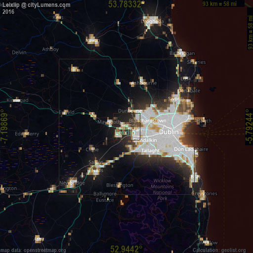
Analysis of Leixlip night lights 2016
Square area 10x10 km:
100  9.66%
9.66%
90-99 10.71%
80-89 5.82%
70-79 2.38%
60-69 5.29%
50-59 6.22%
40-49 8.73%
30-39 8.73%
20-29 16.67%
10-19 22.62%
0-9 3.17%
9.66%90-99
10.71%80-89
5.82%70-79
2.38%60-69
5.29%50-59
6.22%40-49
8.73%30-39
8.73%20-29
16.67%10-19
22.62%0-9
3.17%Square area 50x50 km:
100 8.26%
90-99 5.48%
80-89 1.83%
70-79 1.92%
60-69 1.84%
50-59 1.68%
40-49 2.23%
30-39 2.72%
20-29 4.8%
10-19 10.08%
0-9 59.15%
8.26%90-99
5.48%80-89
1.83%70-79
1.92%60-69
1.84%50-59
1.68%40-49
2.23%30-39
2.72%20-29
4.8%10-19
10.08%0-9
59.15%Clear (daylight) street map image can be seen on geolist.org.
Map coordinates:
53° 46' 60" North, 7° 11' 55.3" West
53° 21' 57" North, 6° 29' 44" West
52° 56' 39.1" North, 5° 47' 32.8" West
Some cities around Leixlip sort by population:
• Celbridge
4.2 km =2.6 mi,  230°
230°
• Lucan
3.3 km =2.1 mi,  106°
106°
• Clondalkin
8 km =5 mi,  125°
125°
• Maynooth
6.8 km =4.2 mi,  288°
288°
• Palmerstown
8 km =5 mi,  102°
102°
• Dunboyne
6.1 km =3.8 mi,  13°
13°
• Hartstown
5.5 km =3.4 mi,  56°
56°
• Confey
1.5 km =0.9 mi, 12°
2962974 (p: 15,452)
Sources (retrieved 2019-11-25):
» Earth at Night: Flat Maps 2012, 2016